"La vall de la Llosa" is the name of the valley where Llosa
river follows from its begin under peaks higher than 2900m, until the
end at Cerdanya's Valley (1000m high).
It's a valley with no human presence (only a few houses and a couple of little villages named Viliella and Martinet.
It's North-South oriented in the Pyrenees. It forms a natural border with France and Andorra.
When you go trough it, you can find som rivers and streams, and a some groups of lakes such as Vallcivera, Montmalús, Engaït or Muga
The mountains that close this valley and the rivers that feed it are placed between 2.700 i 2.900 m. high. We are talking about the following peaks: Tossa Plana de Lles (2.916 metres), la Muga (2.860 metres), Montmalús (2.782 metres), Pic Negre d'Envalira (2.821 metres).
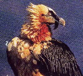
"La vall de la Llosa" is a protected area. It's a natural reserve. There are some protected species of animals as: bearded vultures (Gypaetus barbatus), white partridges (lagopus mutus) , capercaillies (tetrao urugallo) , chamois (rupicapra rupicapra pyrenaica). There are also marmots (marmota marmota), deer (cervus elaphus hippelaphus), foxes (vulpes vulpes), wild boars (sus scrofa), etc.
There are oak woods
(quercus pubescens) and ilex (quercus ilex rotundifolia) in the lowest
parts, and grassland in the highest areas, but black pines (pinus uncinata)
represent the main vegetation