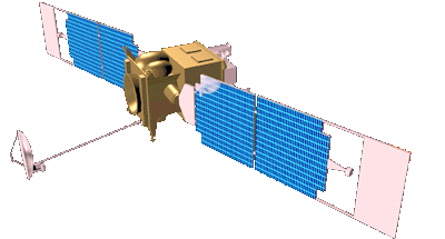
Mars Global Surveyor


Back to the Astronomy main page


Recent Images  
All photos NASA.


Some Results From The First 6 Weeks In Orbit

Mars Global Surveyor (MGS) Mars Orbiter Camera (MOC) images acquired shortly after orbit insertion were relatively poor in both resolution and image quality. This poor performance was solely the result of low sunlight conditions and the relative distance to the planet, both of which have been progressively improving over the past six weeks. Some of the better images are used below to illustrate how the MOC images provide substantially better views of the martian surface than have ever been recorded previously from orbit. This finder chart provides an overall view of the areas imaged, using a U. S. Geological Survey shaded relief map. The approximate locations of the MOC images to be discussed are indicated by their ID numbers (1303, 2306, 2802).
 
 
A (44 KBytes) 

 
B (272 KBytes

 
C (268 KBytes)

Tithonium/Ius Chasmata (Orbit 13, Image 3)

On October 3, 1997, the MOC acquired this image of the western Tithonium Chasma/Ius Chasma portion of the Valles Marineris, centered at 6.6°S, 90.4°W, at 1:16 PM PDT. Although the lighting beneath the spacecraft was very poor, the camera was canted towards the sun, and the illumination was equivalent to roughly 5 PM local time (the sun was about 17° above the horizon). In the image, the canyon floors are mostly shadowed, but steep slopes in the area are exquisitely highlighted. 

The area outlined in (A), the highest resolution view of the region previously available, is 6.6 km (4 miles) wide by 55.6 km (34.5 miles) long. The ridges to the north and south are about 4000 m (13,000 feet) above the floor of the troughs, but in the area photographed, the relief is slightly lower (about 3000 m, or 10,000 feet). The top portion of the image is shown in (B), and a section of that image is shown enlarged in (C). The scale is 6.45 m/pixel across the image by 9.65 m/pixel down the image. 

Most remarkable about the MOC image is the discovery of light and dark layers in the rock outcrops of the canyon walls. In the notable, triangular mountain face [center of (B) and at the top of (C)), some 80 layers, typically alternating in brightness and varying in thickness from 5 to 50 meters (16 to 160 feet), are clearly visible. This shear mountain cliff, over 1000 m (3200 ft) tall, is only one of several outcrops that, together, indicate layering almost the entire depth of the canyon. 

This type of bedrock layering has never been seen before in Valles Marineris. It calls into question common views about the upper crust of Mars, for example, that there is a deep layer of rubble underlying most of the martian surface, and argues for a much more complex early history for the planet. 

Malin Space Science Systems and the California Institute of Technology built the MOC using spare hardware from the Mars Observer mission. MSSS operates the camera from its facilities in San Diego, CA. The Jet Propulsion Laboratory's Mars Surveyor Operations Project operates the Mars Global Surveyor spacecraft with its industrial partner, Lockheed Martin Astronautics, from facilities in Pasadena, CA and Denver, CO.


A (83 KBytes) 


B (183 KBytes)
 
C (270 KBytes)
 

Schiaparelli Crater (Orbit 23, Image 6)

This view of Mars, showing a small area immediately south of the large crater Schiaparelli, was taken by the Mars Orbiter Camera during its 23rd pass close to the planet. It was acquired on October 18, 1997, at 3:42 PM PST, about 10 minutes after closest approach. The image covers an area 4.6 km (2.9 miles) wide by 21.1 km (13.1 miles) high, at a resolution of 4.5 m by 7.9 m (14.75 X 25.9 feet) per picture element, and is centered at 5.5°S, 340.7°W. The local time of the acquisition was about 4:50 PM. 

(A) shows the location in the best available image from the Viking Orbiters (approximately 240 m/pixel). (B) is the full image, while (C) is an enlarged portion of (B). 

There are two exciting results seen in this image. First, the small dunes moving from left to right (north to south) along the canyon floor are apparently derived from bright deposits within Schiaparelli crater. They are brighter than most martian dunes and may represent a unique composition. The shape of the dunes, and their relationships to one another, strongly suggest that these dunes have been active recently, although whether that means within the past year or the past century cannot be told from these images alone. 

The second discovery made in this image are the small depressions found in the upper left and center of image [best seen in (C)] with faint dark lines crossing lighter floors. These depressions, and the pattern of lines, are similar to dry lake beds seen throughout the deserts of the southwestern United States. The light material may be salts or other minerals deposited as the lake evaporated, and the dark lines may be cracks created as the material dried out. Alternative explanations for the dark lines, involving freezing and thawing of water-saturated soil, are equally intriguing. In both cases, these features are the examples of a suite of such forms that can be used to diagnose the amount and distribution of surficial water that may have once ponded on Mars.


A (95 KBytes) 
 
 
B (137 KBytes)
 
C (170 KBytes)
 

Ganges Chasma (Orbit 28, Image 2)

Complex Floor Deposits Within Western Ganges Chasma, Valles Marineris. On October 26, 1997, MOC took this image of Mars 10 minutes after its closest approach to the planet (1:46 AM PST). The view shows the floor of western Ganges Chasma (7.8°S 51.8°W), covering an area 2.6 km (1.6 miles) wide by 45.4 km (28.2 miles) long at a resolution of 5 by 7.4 meters (16.4 by 24.3 feet) per picture element. The local time on Mars when the picture was taken was 4:35 PM. 

This image, portions of which are presented in (B) and (C) at full resolution, is roughly 50 times better than the previous best image, shown in (A). 

(B) shows the area near the canyon wall, where large block of the upland surface have slumped down into the canyon. Close inspection of this image shows numerous small dark dots that are in fact individual rocks on the surface of Mars. These rocks vary from the size of a small automobile to the size of a house, have fallen down steep slopes. 

(C) shows a remarkable landscape of ridges and troughs that very closely resemble folded and warped sediments on Earth. This is the first time such warped beds have been seen on Mars, and neither their origin nor their occurrence within Ganges Chasma is understood. It is possible these are beds folded by a large landslide, but that would be very unusual. Alternatively, these may be folded sedimentary beds, similar to horizontal beds seen elsewhere in Ganges Chasma. However, what forces then folded these particular beds while leaving the others undeformed is unknown. Future imaging within this and the other Valles Marineris will be used to address such issues.


This movie (3921K) was created by combining the eight MGS/MOC MOI-22 day approach images into a map of Mars, and then digitally reprojecting that map onto a sphere. This is the same process used by the Hubble Space Telescope team in making its rotation movie from HST data (699K). The HST data were acquired when Mars was viewed more or less "face on," whereas MGS/MOC viewed the planet at half-phase. Thus, each of the eight MOC images required processing to remove the overall shading (the photometric function). Software provided by the Hubble Space Telescope Mars Monitoring team was used for this purpose. This software was also used to create a map projection of each image. These were then mosaiced together to create a map of the visible part of the planet (areas south of 66.4°S were not ever seen). Owing to foreshortening in the polar regions, some cosmetic processing was needed in areas south of about 35°S as well. Once the final map was created, a limited amount of enhancement was applied to sharpen features, and the resulting image was "mapped" onto a sphere using computer graphic software. A camera within this software was place at a relative distance and appropriate magnification to recreate the view seen from MGS, and an illumination source was set at the right location to simulate the sun. A set of test images were then created to compare with the original images. When the simulation recreated the input images, the rotation of the planet was simulated, and the camera position moved to observe the planet "face-on." 
 
Mission itinerary.
 
Mars Orbit Insertion. 
 
Mars mapping phase.

MGS spacecraft 
Before the launch 
On the way to Mars! 
Trajectory 
The Mars Global Surveyor is designed to orbit Mars over a two year period and collect data on the surface morphology, topography, composition, gravity, atmospheric dynamics, and magnetic field. This data will be used to investigate the surface processes, geology, distribution of material, internal properties, evolution of the magnetic field, and the weather and climate of Mars. 

After launch on November 7, 1996, at 12:00:50 EST and a 10 month cruise phase, it was inserted into an elliptical capture orbit in September 11, 1997. Over the next four months, aerobraking maneuvers will be used to change the orbit the the final mapping orbit at an altitude of 378 km, an inclination of 92.9 degrees, and a low eccentricity of 0.0072. This final orbit will be sun-synchronous, so data will be collected with the sun at the same mid-afternoon azimuth for each pass. After one martian year (from January, 1998 until December, 1999), the orbiter will act as a relay in suport of other missions of the Mars Surveyor program, until January 2003. The spacecraft is a cubic box 1.17 m in size and 1 ton of weigth. The main 596 N thruster use hydrazine and N2O4 propellant. Control will be through 12 4.45 N hydrazine thrusters, mounted in groups of three. The initial propellant load will be 216.5 kg of hydrazine and 144 kg of N2O4. Solar panels will provide 667 W of power at aphelion. The instruments are basically the same that equipped the spacecraft Mars Observer, lost in 1992: 

It is equipped with a 8086 processor for the payload data subsystem and two 1750A processors for standard control and data formatting. Data will be stored on four 0.75 Gb solid state recorders. 

On December 4, 1996 was successfully launched Mars Pathfinder. It reached the red planet on July 1997, about two months earlier than MGS, because its faster trajectory. 

These are the first two missions to Mars of a total of ten that the United Satates have planned before year 2006. Russia, Japan and Europe have also sheduled missions to Mars for the same period.


Orbiter 

 
Lander

The Mars Surveyor Program for the 1998 Earth-Mars transfer opportunity consists of a lander and an orbiter mission both managed by the 1998 Mars Surveyor Project at the Jet Propulsion Laboratory for NASA. The orbiter and lander spacecraft will be launched in December 1998 and January 1999 respectively, on separate Med-Lite launch vehicles (Delta 7425 configuration) procured by NASA from McDonnell Douglas. The general science theme for the 1998 Surveyor misions is "Volatiles and Climate History." The specific science payload elements for the lander and orbiter missions were selected by NASA through a competitive announcement of opportunity in October 1995. The 1998 Surveyor spacecraft is being procured from Lockheed Martin Astronautics of Denver, Colorado, via a single system contract for both the lander and orbiter flight systems. 

Visit the MGS project web page at NASA:

Malin Space Science Systems and the California Institute of Technology built the MOC using spare hardware from the Mars Observer mission. MSSS operates the camera from its facilities in San Diego, CA. The Jet Propulsion Laboratory's Mars Surveyor Operations Project operates the Mars Global Surveyor spacecraft with its industrial partner, Lockheed Martin Astronautics, from facilities in Pasadena, CA and Denver, CO.