Temes de Ciència


WEATHER FORECASTING TO PREDICT TORNADOS
ECLIPSI DE SOL: 3 d'octubre de 2005
Temes de Ciència |
|
|
WEATHER FORECASTING TO PREDICT TORNADOS
ECLIPSI DE SOL: 3 d'octubre de 2005
|
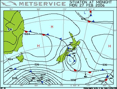
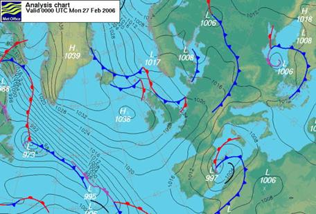
Weather forecasting to predict tornados Meteorologists collect data about current weather condition from a widespread system of observing stations (global weather data are collected at more than 1000 observation points around the world). All forms of forecasting make use of numerical data such as temperature, atmospheric pressure , and humidity. The trend method is based on the knowledge that weather conditions are strongly influenced by the movement of air masses and by the existence of similar maps in the past. ISOBARS
Isobars are lines that connect points of equal pressure on weather maps. The word originates from Greek, where isos means equal and baros means weight. The isobar lines are always referred to sea level. An important consequence of air pressure differences is wind , because wind blows from areas of high pressure to areas of low pressure. The greater the pressure contrast and the shorter the distance, the faster the wind will blow, so closer isobars mean faster wind. Isobars are useful for weather analysis or forecast. We can expect the winds blow from high pressure to low pressure, but because of the effect of the rotation of the earth, in the Northern Hemisphere the winds tend to blow clockwise round an anticyclone (area of isobars surrounding a high-pressure area) and anticlockwise round a cyclone (area of isobars surrounding a low-pressure region). South of the equator the situation is reversed. Air Masses and Fronts
An air mass is an extensive body of air that has a relatively homogeneous temperature and humidity content over a significant altitude. A front is the boundary at which two air masses of different temperature and moisture content meet. Certain locations on the earth's surface possess the topographical characteristics that favour the development of air masses. The two most important of these characteristics are topographic regularity and atmospheric stability. Deserts, plains, and oceans typically cover very wide areas with relatively few topographical irregularities. In such regions, large masses of air can accumulate without being broken apart by mountains, land/water interfaces, and other features that would break up the air mass. The absence of consistent wind movements also favours the development of an air mass. The movement of air masses across the earth's surface is an important component of the weather, they can bring with them cold temperatures, strong winds, and heavy precipitation . When a mass of cold air comes into contact with a warm air mass, the cold air mass may force its way under the warm air mass, because the cold air is denser than the warm air. The boundary formed between these two air masses is a cold front . Cold fronts are usually accompanied by a falling pressure and the development of large cumulonimbus clouds that bring rain showers and thunderstorms. Cold fronts are represented on weather maps by lines that contain triangles at regular distances along them. The direction in which the triangles point shows the direction in which the cold front is moving. A situation opposite to the preceding is when a warm air mass approaches and slides up and over a cold air mass. The boundary formed in this case is a warm front . As the warm air mass meets the cold air mass, it is cooled and some of the moisture condenses to form clouds. Warm fronts are designated on weather maps by lines with half circles. The direction in which the half circles point shows the direction in which the warm front is moving. In some instances, the collision of two air masses results in a stand-off. Neither mass is strong enough to displace the other, and essentially no movement occurs. The boundary between the air masses in this case is known as a stationary air mass and is designated on a weather map by a solid line with triangles and half circles on opposite sides of the line. Stationary fronts are often accompanied by fair, clear weather, although some light precipitation may occur. THUNDERSTORMS Thunderstorms happen quite often in summer, but in fact they can happen at any time of the year. The main things a thunderstorm needs are damp air near the ground and a layer of much colder air above it. The Warmer air rises, taking water vapour with it. The water vapour condenses into water droplets, making a cloud. The water vapour in this air condenses to form more water droplets as it rises and cools. When water vapour condenses, it releases latent heat. This warms the air and forces it to rise more vigorously, strengthening the storm. The cloud grows and rises up to 10 km high. Even in summer the air at 3 km or so is so cold that water freezes. The top of the cloud is made of ice crystals. The streams of cold and warm air flowing past each other in different parts of the cloud produce electrically charged particles (ions) due to friction. The top of the cloud becomes positively charged, the bottom becomes negative and there is a huge voltage between the cloud and the ground. A lighting flash starts with a fairly small current that jumps between different parts of the cloud or between the base of the cloud and the ground. As it does so it makes more ions. This allows a much bigger current to flow, which usually goes from the ground up to the cloud. This return stroke may carry a huge current, possible 10 000 amperes. It last less than a thousandth of a second. Tornados
Tornadoes are the most violent of all wind storms. A tornado occurs over land and is a revolving cyclonic storm. It has a fairly small diameter, but has a high intensity. A tornado appears as a funnel extending out from the cloud base (vortex). A tornado hangs from the bottom of a single thunderstorm. In their early and mature stages, all thunderstorms are characterized by rising air, called updrafts. These updrafts supply the warm, humid air that fuels thunderstorms. Often, a tornado is located on the edge of the updraft, next to air that's coming down from the thunderstorm with falling rain or hail. This is why a burst of heavy rain or hail sometimes announces a tornado's arrival. The centre of the tornado's vortex is a low-pressure area. As air rushes into the vortex, its pressure lowers, which cools the air. Cooling condenses water vapour in the air into the tornado's familiar funnel-shaped cloud. As the swirling winds pick up dust, dirt, and debris from the ground, the funnel turns even darker. Twisters that pick up little dirt can retain their white, cloud coloration. Some tornadoes have taken on a red hue by picking up red dirt. Although the air is rising in a tornado, the funnel itself grows from the cloud toward the ground as the tornado is forming. The term "funnel cloud" refers to a tornado-like vortex that doesn't reach the ground. When a funnel cloud touches the ground, it becomes a tornado. The ingredients are: a big thunderstorm; winds blowing from opposite directions; and a strong updraft. Strong updrafts surge up through storm clouds, these clouds will become a severe storm capable of producing tornadoes only under certain circumstances. Severe storms are often associated with a very unstable atmosphere and moving low-pressure systems that bring cold air into contact with warmer, more humid air masses. A tornado can form when the air in these updrafts begins to rotate as opposing winds cause the storm to start spinning. The exact mechanism of tornado formation inside severe thunderstorms is still a matter of dispute, but it appears that tornadoes grow in a similar fashion to the small vortices that form in draining bathtubs. Tornadoes appear to be upside down versions of this phenomenon. As updrafts in a severe thunderstorm cloud get stronger, more air is pulled into the base of the cloud to replace the rising air. Some of this air may be rotating slightly since the air around the base of a thunderstorm usually contains some rotation , or vorticity. As the air converges into a smaller area, it begins to rotate faster due to a law of physics known as the conservation of angular momentum. This effect can be seen when an ice skater begins spinning with arms outstretched. As the skater brings his or her arms inward, his or her rotational speed increases. In the same way, air moving into a severe storm begins to move in a tighter column and increases its rotational speed. The rapid air movement causes the surrounding air pressure to drop, pulling more air into the growing vortex. The lowered pressure causes the incoming air to cool quickly and form cloud droplets before they rise to the cloud base. Tornadoes are also relatively small. An average tornado will be 400 to 500 feet wide and travel four or five miles on the ground, lasting only a few minutes. A mile-wide tornado is an extremely large one and tornadoes this big is rare. Many tornadoes are small, less than 100 feet wide, and last only a few minutes. Winds rarely exceed 250 mph and most tornadoes have winds of less than 112 mph. In a few cases, the vortex becomes a strong tornado with wind whirling around at speeds close to 300 mph. Although tornadoes occur in many parts of the world, these destructive forces of nature are found most frequently in the United States east of the Rocky Mountains during the spring and summer months. The United States is the tornado capital of the world with an average of 700 tornadoes per year. The U.S. has this many tornadoes because of west winds. Winds from the west are forced to stream over the Rocky Mountains . On the other side these winds encounter the low, warm, moist winds from the Gulf of Mexico . These two air masses collide over the central U.S and provide the possibility for tornado development. That's why Kansas had more than 1200 tornadoes from 1953 to 1980 while Alaska only had one.
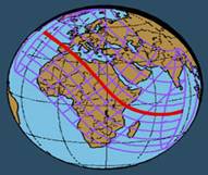
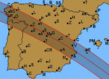
3 d'octubre de 2005 Els eclipsis de Sol són fenòmens que es produeixen quan la Terra, la Lluna i el Sol queden alineats de tal manera que la Lluna projecta la seva ombra sobre la superfície de la Terra. Depenent de les distàncies Terra-Lluna i Terra-Sol, l'ombra de la Lluna pot arribar o no a tocar la superfície de la Terra. Quan se sumen les circumstàncies d'una distància Terra-Lluna gran i una distància Terra-Sol petita, el disc de la Lluna no arriba ser suficientment gran per amagar tot el disc solar i es produeix un eclipsi anular. En aquest cas, durant la fase central del fenomen, resta al voltant de la Lluna un anell lluminós, corresponent a la superfície del Sol no amagada. Aquest és el fenomen que podrem veure des de la Península Ibèrica el matí del 3 d'octubre de 2005. • Diàmetre de la Terra: 12.742 km • Diàmetre de la Lluna: 3.476 km • Distància mitjana Terra-Lluna: 384.400 km • El diàmetre del Sol: 1.391.000 km Tant la distància Terra-Sol com la distància Terra-Lluna és variable. El dia de l'eclipsi, 3/10/2005 aquestes distàncies han sigut, respectivament, 149.695.594 i 397.400 km. L'eclipsi es va iniciar a les 9:43 (hora oficial) quan el sol va estar a 20º altitud. La ocultació màxima va ser a les 11:03 amb el Sol a 32º i el darrer contacte va sera les 12:30 amb el Sol a 42º. Per calcular les mides que hauria de tenir el model, partim dels valors reals. En termes generals, l'eclipsi va començar sobre la Península Ibèrica cap a les 7h 38m UT del matí i va acabar cap a les 10h 33m a les Illes Balears, en Temps Universal . (Temps Universal, UT = sumar-hi 2 hores per a l'hora oficial peninsular i 1 hora per a la canària) La zona de visibilitat va abastar part de Groenlàndia, Europa, Àfrica excepte l'extrem sud i el sud-oest d'Àsia. La franja central d'anularitat travessarà la Península Ibèrica de nord-oest a sud-est, per endinsar-se després a l'Àfrica per Algèria, i sortint per Somàlia.
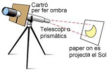
Com observar-lo? Recordeu que MAI es pot mirar el Sol sense protecció , ni tant sols quant l'eclipsi és avançat i la llum disminueix. Hi ha perill de lesions oculars. Cal utilitzar les ulleres amb filtres homologats. Utilitzar ulleres de sol o qualsevol altre filtre casolà pot ser encara més perillós. Els aparells òptics s'han d'utilitzar per projectar la imatge del Sol sobre un paper o una pantalla. No cal tenir un gran telescopi, amb uns prismàtics la imatge que es projecta ja és prou nítida si està a l'ombra.
Mai hem de mirar directament el Sol amb telescopi o prismàtics.
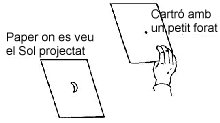
Si no tenim ni ulleres ni cap aparell, busqueu dos fulls de cartolina. En un d'ells feu un petit forat i projecteu la llum del Sol que passa per aquest foradet sobre l'altre full.
Man's main sources of chemical energy are petroleum, natural gas, and coal . We are now in a position to examine how these materials are used to make the fuels and chemicals needed to move our vehicles, heat our homes, and produce the many substances, such as textiles, paints, and plastics, manufactured by the chemical industry. PETROLEUM: At present, petroleum and natural gas rank as the main source of not only our fuels but the bulk of the organic chemicals used in industry . Petroleum, or oil, is found in underground deposits in many regions of the earth. Its origin lies in plants and animals which lived on the earth and in the sea many millions of years ago. The residues from these organisms accumulated in certain regions, possibly as a result of geologic conditions, became buried, and were subjected to high pressures and reducing conditions over long periods of time. The resulting material, petroleum is a complex mixture of hydrocarbons, containing paraffinic chain and ring molecules, aromatic molecules, and small amounts of oxygen- and sulphur-containing substances. Petroleum has been known for thousands of years, being observed as surface seepages, particularly as oil films on streams and ponds. It had no known use, except as medicine oil, until about the mid-nineteenth century when the first oil wells were drilled in the United States and Rumania . Crude oil, on being distilled, yielded a fraction known as kerosene, which had immediate commercial importance as a lamp fuel; for many years kerosene was the main product of the petroleum industry. As a result of petroleum research, refining processes, chemists are able to manipulate the end products of the petroleum to meet many different kinds of demands, from home heating gases to jet fuels to road asphalts, in the way which makes best use of the starting material. A by-product of this research has been the petrochemical industry. Following a rough distillation of the crude oil into the fractions indicated in Table, the higher molecular mass fractions are carried through a controlled pyrolisis or cracking process, in which they are heated at about 500ºC, often under catalytic conditions. In this process the molecules suffer a rupture of a carbon-carbon bond, yielding olefins and paraffins of lower molecular mass than the original fraction. The product contains a substantial fraction of substances which boil in the same range as gasoline, thus increasing significantly the yield of gasoline from crude oil. The lighter olefins, particularly ethylene and propylene, have in recent years found a market as raw materials in the plastic industry. Isooctane resists knocking very well and is assigned an octane number of 100. Heptane is very prone to knocking; its octane number is 0. Gasoline with the same knocking properties as a mixture of 90% isooctane and 10% heptane is known as 90 octane. NATURAL GAS: Above many petroleum deposits there is a gas, called natural gas, mixture of light paraffins, roughly 75% methane, 15% ethane, 5% propane, and higher hydrocarbons. This material is also found in many places in the earth where there is no petroleum. The natural gas used in homes is a mixture of methane and ethane, essentially a perfect fuel for heating or cooking . The propane and butane are removed as liquids by compressing and cooling the gas; This LP (Liquefied Petroleum) gas has a wide market where pipeline gas is not available. The main market, however, for natural gas is currently the chemical industry, which uses it as raw material for the production of many important substances (ethylene, methyl alcohol, acetylene, ammonia ). COAL: Coal is a solid organic material, usually black or dark brown in colour, found in layers in many parts of the earth. Like petroleum, coal has its origins in the plant material that lived on earth about fifty million years ago. Over eons of time this material (under the conditions of pressure and temperature that prevailed) gradually has changed its composition, losing hydrogen and oxygen and increasing its relative carbon content. Coal is a complex mixture of many substances; the composition of a given coal sample may vary widely, and will depend on its age, history, and the nature of the living material from which it came. Coal contains mostly carbon, much of which is bound in fused aromatic rings, similar to those in graphite, but with much less extensive structures. In addition to carbon, which makes up about 70% by mass, coal also contains about 6% in hydrogen, 10% oxygen, 2% sulphur, 1% nitrogen, and about 10% of other elements, all for the most part in chemical combination with carbon. Coal is obtained from both underground and surface mines; it is found in layers or seams, which vary in thickness from about 1 to 3 meters. The technology for coal recovery from both deep and surface, or strip, mines is well developed, with automatic machinery making possible very high worker efficiency. Both types of mining operation have negative effects on the environment. |
|---|