Geographical
Notes Geographical
Notes
The insular position of
the British Isles but the fact that they are very close to the Continent
has been a great advantage for the British Isles throughout history. Geographically
speaking, the British Isles can be divided into three parts:
-
England: We can identify
two distinct areas, the Lowlands (the London and Hampshire Basins,
the Midlands, East Anglia, the Fenlands, Lincolnshire and Eastern Yorkshire)
and the Highlands (the Western Highlands in Cornwall and Wales,
and the Northern Highlands in the Pennines and the Cumbrian Mountains).
-
Scotland: We can identify
four distinct areas, the Southern Uplands in the south, the Central
Lowlands (Edinburgh and Glasgow), the Northern Highlands (Aberdeen
and Dundee) and the Islands (the Hebrides, the Shetlands and the
Orkneys).
-
Ireland: The smallest
of the British Isles is called the Emerald Island due to its green
pastures.
|
Climate
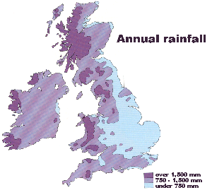 |
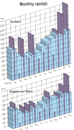
The climate in
the British Isles is oceanic(humid
and temperate)
and there is
abundant rainfall.
|
Political
Division
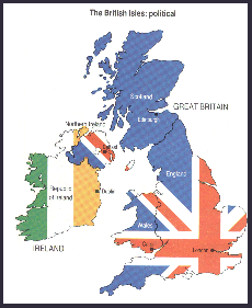
The geographical
division noted above, however, does not coincide with the political division
of The British Isles:
-
The United Kingdom is
formed by Great Britain (England, Wales and Scotland)
and Northern Ireland.
-
The Isle of Man and The
Channel Islands, which are crown dependencies, but not part of the
United Kingdom.
|
|
|
Maps
taken from Britain Explored by Paul Harris and Rhodri Jones (Longman,
1992)
|